• This forum is strictly intended to be used by members of the VS Battles wiki. Please only register if you have an autoconfirmed account there, as otherwise your registration will be rejected. If you have already registered once, do not do so again, and contact Antvasima if you encounter any problems.

    For instructions regarding the exact procedure to sign up to this forum, please click here.
  • We need Patreon donations for this forum to have all of its running costs financially secured.

    Community members who help us out will receive badges that give them several different benefits, including the removal of all advertisements in this forum, but donations from non-members are also extremely appreciated.

    Please click here for further information, or here to directly visit our Patreon donations page.
  • Please click here for information about a large petition to help children in need.

Fiore's Proper Diameter (Very Important)

Status
Not open for further replies.
@iMade

Sorry, but the newer map doesn't make sense when it comes to where cait shelter is. It's simply hiro forgetting where he put cait shelter in the first place rather then saying it was retconned since we have no proof of any retcons.

Also both map put hargeon at the edge of the country, and we see this in the anime and in the manga. To say that hargeon is not on the edge of the country when both the manga and anime says otherwise, is just being stubborn.
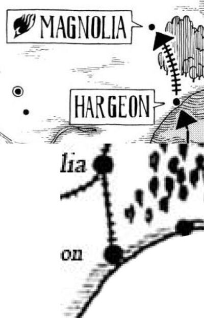
 
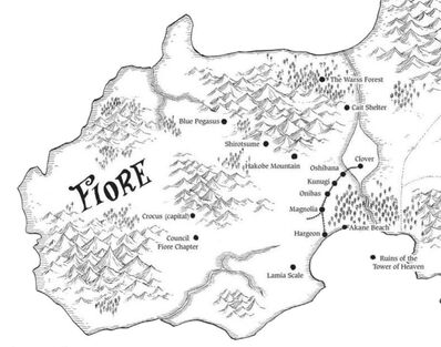
Both Maps prove that Hargeon is right next to the edge of the Country, basically a pixel away from the border, the Wide Ouline is not actually part of the Country, adding that as part of the equation, would deflate the country unrealistically, as the outside white line is not part of the country

we keep going back and forth, but this is going nowhere, only One calc member has given his opinion at this moment, and he agrees with my side, all we can do is wait for one of the numerous calc members I have asked to comment
 
Can I just ask why we even care where the dot's exact position is? We know where Hargeon is roughly and every map we have agrees on it. The only difference I can see between the two arguments appears to be whether we treat the white strip in the more recent map as part of Fiore. All we need to do is ask ourselves the following questions and vote.

1. Do all of us also agree that Hargeon is on the coast/right next to the water?

2. If yes, should we treat the white outline as part of Fiore and measure the coastline from the inside of it or the outside?

I'll start the vote

Part of Fiore (measure from the outside):

Not part of Fiore (measure from the inside): AnonymousBlank, DemonGodMitchAubin, KaiserReinhardt
 
I of course, believe it does not
Fiore Map Measurement (2)
, adding the border would unrealistically decrease the size of the Country, also as you can see below, without the border, the two Maps look almost exactly the same, proving that the border is not part of the map, also just accepting that the dot of Hargeon is in the wrong place is denying the Map in general, if we can't trust the markers, how can we trust the Map, the point is, the WHITE BORDER IS NOT PART OF FIORE
 
I agree with measuring from inside, the outside border looks like a sea border and there is no reason for us to use that when we're trying to calculate the size of fiora.

"Hargeo (ÒâÅÒâ½Òé©Òé¬Òâ│ Harujio) is a large port town." It's at the very edge of the country, and it's 370km away from magnolia and this a fact stated in the manga.
 
I also want to point out, that the White Border is actually water, as you can see in the Map, The White border melts into many rivers proving that it is water and not part of the land itself, meaning the white border shoulf not be counted, when measuring land
 
Island Town Maybe, I do know the Railway goes over a giant ravine, to get to Clover Town
 
Thats what I figured too before remembering that Team Natsu destroyed a mountain(s?) when they fought Lullaby and there were plenty of mountains left after they finished.
 
KaiserReinhardt said:
@iMade
It's simply hiro forgetting where he put cait shelter in the first place rather then saying it was retconned since we have no proof of any retcons.
This is asinine thinking. We do have proof of retcon by the fact that Hiro has changed the location of Cait Shelter in his new map. Hiro has retcon so many times too in Fairy Tail. Recall the walking city robot? Hiro said in his own volume extras that he retcon the amount of legs it had. Recall the villain from Oracion Seis, Racer? Hiro retcon Racer's speed and magic about 3 times in the series.

Yes, Hiro does retcon and we are shown here that he retcon this map from Chapter 165 thus that map is no longer usable. Which is why we should use the more updated map that Hiro himself has made.

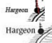
Plus again, no map has Halgeon touching the borders nor ocean. Torch himself based his calc on the black dot of Halgeon:
Halgeon Not Touching Ocean
New Map Doesn't Have Halgeon Touching the Border/Ocea

Halgeon Comparison
Torch's Calc (Top) Official English (Bottom)

>Just to clear things up, my calculation scales to the far end of the Hargeon port town(dot), not the border.

And we are even shown in his calc that he did not touch even the closer outline.

I have been advocating on using the more recent Official English Map, which only I have been using in this discussion and in my calcs. This map shows Akane Beach touching the outer border/outline and directly touching the ocea which Halgeon Port would also be doing as Dimaria discussed and showed us the harbor/dock of Halgeon Port is touching the ocean.

Conclusion: There are too many issues with the first map, it has been retcon, it does not have Halgeon touching the ocean and we can't even use that map to find a size of Fiore since it does not show us all of Fiore. The official English map is of much higher quality and better to use, even that one does not have Halgeon touching the closer border; however, it does show us a beach touching the ocean which is where Halgeon Port that Dimaria was talking about would be at, thus let us use that outer border to begin our 370 kilometers.

But again, we are just clogging this thread up. We've made our points and repeated them. None of us voting will do anything since it's up to the Calc Group.
 
Ok NOW I can see the difference between the two. Yeah I can see that the rope is touching the line but the bottom isnt
 
I agree with using the edge of the country and not just the dot and I agree with using the current map, however the White Border is NOT part of the country's land, it's water, that's why is runs into the rivers, because it is water, the old map also agrees with this, as there is no white border because it's all water and rivers, using the white border is wrong and deflates the Country's size, TataHakai, a Calc Member agrees with this, and we need other calc members to comment, I have asked 6 at least, all I have to do is wait for them to give their opinions
 
@iMade

But how do you know it's a retcon rather then a hiro forgetting where cait shelter was and misplacing it in his new map. What proof do you really have that indicates that this is indeed a retcon. It makes more sense to say that the author forgot rather then saying it's a retcon, since authors has shown to forget where they put certain things in their stories.

Also where not using the map from chapter 165 to measure fiora since it doesn't show the whole of fiora. We're just point at the fact that both map shows hargeon at the edge of the country and that the outside border is nothing but a sea border. When calculating fiora, we're not gonna use a sea border since that's just dumb.
 
Here is an Image of Fiore without the white Border, so this is the real Area we should use to measure
Fiore Real Area
 
Sea border
Just a example

What iMade is trying to calculate from is the same lines you see in this picture, rather then calculating the land itself.
Maritime boundary

I don't agree with using sea borders, when trying to calculate the size of a country's land. It simply doesn't make sense.
 
Homu Sweet Homu said:
Can't we just get the raw images if English ver is being questioned here?
If you can find the raws of Volume 27, be my guest honestly.

@Mitch

My calc is not based on maritime boundary, it's based on the further outline of Fiore that touches the ocean and that a beach touches which would be similar to a dock/pier.

Also, you would need to prove that Hiro forgot, I can prove he retconned the map based on the fact that he changed/updated it with the latest version. It's on you to prove that Hiro had forgotten since this tells us he retconned.
 
@Mitch

To say that it's a retcon, is a huge claim that needs a proof to back it up. But to assume that a author can forget where he place a certain thing in his story is something that often happens in many stories, and fairy tail is not a exception from this. The fact that cait shelter changed position from the old to the new map for no absolute reason, tells us that hiro either misplaced it or forgot the original place where cait shelter used to be at and those changed it.

So when it comes to cait shelter, i will rather use the old map since that makes more sense then the new one.
 
The outer boundary line is water, it's proven by the fact that it becomes rivers throughout the map, therefore it would not be part of the land, and should not be counted in the measurements, this is backed by the fact that the older map which has Magnolia and Hargeon in the same place with no outer border, therefore we should leave out the white border in the calculation
 
Mitch is correct that if TataHakai has selected his version of the calculation, that is what we preferably should use, although it would be better with more calc group input.
 
It would be better with more calc Input however No one else has responded in 2 full days, and I have contacted many members, maybe they'd also later give Input, however TataHakai decided to go with my method, and I think it's alright to go with Captain Torch and My Method of scaling Fiore
 
Staff and Calc stuff takes a while, we have Staff Only discussions going for weeks to months. Plus, the Calc members that will decide upon this will need some time to read everything through that we've discussed.
 
Well, you can message the remaining calc group members to ask them to comment here as well, if you wish.
 
@LordAizenSama

We are debating here, so trying to discredit by point by saying that "we used an outdated map" and "the two of you are trying to find any means to get your end accepted even when you are going against each other's words." is a cheap way to discredit our points. I said my point previously in the discussion, and am staying true to it. "Going against each other's words" just means that while having a similar outlook, we do have disagreements in some places, which is normal when different people are debating for their point.

Honestly, it seems like YOU are the one trying to find any means necessary to get your end accepted. But this is a simple manga discussion, no need to get overly serious about it.
 
They use a similar username image. It seems to be a simple mistake on Torch's part.
 
Oh my bad. I mix them up all the time. They have the same picture, and debate similarly so it's hard to remember who is who sometimes.
 
It's actually quite easy considering one of them was banned over 6 months ago
 
Yeah, and both of them are huge fans of bleach.

And since Imade started being active only recently, I kinda mixed him up. No big deal though.
 
Well that was b4 he saw the difference though. I wouldn't be fair if someone has an ACTUAL difference and he has proof
 
What do mean, "before he saw the difference", he said he agrees with not using the White Border, and just going with the interior outline of Fiore
 
So you agree that TataHakai agreed with me, because he did
 
DemonGodMitchAubin said:
Here is an Image of Fiore without the white Border, so this is the real Area we should use to measure
Fiore Real Area
Mitch posted this picture, and it doesn't have those weird borders that goes into the sea. Measuring the size of fiore using this picture makes more sense then using some weird border that goes into to the sea. Also it doesn't even make sense using a border that goes into the sea, when trying to measure a country's LAND.
 
Well, if no other calc group member replies here, we have to go by TataHakai's decision.
 
Status
Not open for further replies.
Back
Top