• This forum is strictly intended to be used by members of the VS Battles wiki. Please only register if you have an autoconfirmed account there, as otherwise your registration will be rejected. If you have already registered once, do not do so again, and contact Antvasima if you encounter any problems.

    For instructions regarding the exact procedure to sign up to this forum, please click here.
  • We need Patreon donations for this forum to have all of its running costs financially secured.

    Community members who help us out will receive badges that give them several different benefits, including the removal of all advertisements in this forum, but donations from non-members are also extremely appreciated.

    Please click here for further information, or here to directly visit our Patreon donations page.
  • Please click here for information about a large petition to help children in need.

Fiore's Proper Diameter (Very Important)

Status
Not open for further replies.
As you could see by TataHakai's comments, he was still asking questions and did not fully understand, thus why I had to explain and still must explain.

> Captain's Measurement doesn't just go to the dot, it goes the line, so it is touching the real border, not the Wide Border which is not part of the country

You are now back-pedaling and defeating your own basis. You have been basing your argument and calc on using the dot for your calculations and saying that Halgeon Port would be located in the dot. You are now going back and saying your using the border and not the dot, which does not line up with the words you and Torch have been using to justify this calc.

As I have shown in my comments, that border line is not the outline of the country based on Akane Beach touching the further line and the ocean. The Halgeon port's location would be also be similarly touching the ocean as Dimaria was literally talking about a harbor with a dock built out into sea a bit.

So I would ask again: why would we say "Hey, let's ignore Akane Beach touching the ocean" when the harbor that Dimaria is talking about would also be touching the ocean and that ignoring it wouldn begin the 370 kilometers in the middle of land instead of the coast?
 
DemonGodMitchAubin said:
No Rush, just that a calc Member has decided which way to go with the Calc, and that should be that, we have an answer and we should use it
Generally we wait for multiple calc members, knowledgeable members and/or staff to accept Revisions for our series and threads.
 
Half of the dot is over the border, I know that is true, however what is half of a Beach, the Ocean, the Dot rests on the line, which is the border, because it is part of the Ocean, also TataHakai did Agree with me, he said we should use the Country without the Wide Border, I don't know what else is there to say, your calc would be deflating the results, while mine would be correct
 
An ocean is not half of a beach. A beach is land besides a large body of water. An ocean is an ocean. Akane Beach touches the ocean, but does not go into it per the map, this location would be similar with Halgeon's Port as it has a dock that touches the ocean and even has a dock built into the ocean.

And as I said generally we wait for multiple calc members, knowledgeable members and/or staff to accept Revisions for our series and threads.
 
We'll wait for More Calc Members, Fine, However if they side with me, will you agree that my calc should be used, and that we go with Captains Method of Measurements
 
Just to clear things up, my calculation scales to the far end of the Hargeon port town(dot), not the border.

It's scaled that way since Dimaria clearly said that the distance is between their location and the port, which is a part of Hargeon Town.

The "outer line" of the map shouldn't be used, since it's just an "outline", which authors often draw. I actually didn't include the outline when scaling Fiore in my calc

And about the Akane Beach point, one must not forget that Akane Beach is just that, a beach. And beaches usually include a part of the ocean, since the depth increases gradually, and the water is still a part of the said beach. Which should explain the reason the Akane Beach dot is located ON the "outline".

Also yes, I agree that we should wait for more calc members in order to be 100% sure.
 
@Torch

>Just to clear things up, my calculation scales to the far end of the Hargeon port town(dot), not the border.

You see, you and Mitch are not even arguing the same thing at this point since Mitch said:

>and anyways, Captain's Measurement doesn't just go to the dot, it goes the line, so it is touching the real border...because the way we are calcing the measurement goes to the line, not just the dot, so there should be no issues

It seems the two of you are trying to find any means to get your end accepted even when you are going against each other's words.

As we see with your calc, Torch, you go to the end of the dot on your calc and as you have literally said yourself in this comment. But we know that to be incorrect since the in the Official English version of the map, the dot doesn't even touch the border. Making your's incorrect and contradicting to Mitch's words.

Since it doesn't even touch the closer border, we can't use the edge of the dot to determine the location of the Halgeon Port. Since we know Akane beach touches the ocean on the map and the outer border, it should stand the same for Halgeon Port that touches the ocean in visuals and has a dock built into sea a bit.

Also, on real maps, dots and locations for beaches don't go out into sea. A beach refers to the land by the body of water, it does not refer to the body of water as that has it's own name.
 
First of all the Dot is nearly on the black line, it's like a pixel difference, I'm saying we measure to that line, and Captain Torch did measure to the line, as he measured to the far end of the dot which happens to touch the line just barely, don't try to turn us against each other in order to give your argument more claim, also both maps are the same, one is just the official translations, while the other is fan ones, but they are the same Map and once again, me and Torch are arguing that the Wide Border is not part of the Country and if we assume that you're correct about the Wide Outline, the it contradicts the ANIME AND MANGA, for one Hargeon is the Port Dimaria is referring to, and rests on the edge of the country, if what you're saying is that the outline is part of the Country, Then hargeon is actually in the middle of the country somewhere, and therefore makes the Map Contradict the story, and it therefore becomes unusable, which would mean both of our methods aren't usuable, even tho there is another map that doesn't contain the border at all and has Hargeon resting in pretty much the same place as it is on the Large Map, as well the dots rests on the border because the Beach is half in the water, when you go to a beach Water is part of the Beach, that is common sense, and there are many maps that have Beach dots directly on the border that bleeds into the sea, point is your Calculation completely Deflates the size of Fiore, which is incorrect in many aspects
 
Ok so can any1 tell me what is the upgrade and what is the downgrade?


EDIT: @Demon just said that both methods wouldn't work so that's it then lol
 
@BlackeJan

It's an Upgrade for High 6-A's

And No I only said that it can't be used if we assume Imade's argument is correct, as he is contradicting the story with his argument of Measurements
 
>First of all the Dot is nearly on the black line, it's like a pixel difference, I'm saying we measure to that line, and Captain Torch did measure to the line, as he measured to the far end of the dot which happens to touch the line just barely
Halgeon Comparison
As you can see, that would be incorrect. You didn't even reach the line, and Torch himself as said:

>Just to clear things up, my calculation scales to the far end of the Hargeon port town(dot), not the border.

You two are saying different things, using an incorrect map and ignoring the fact that Halgeon Port would begin at the water line when Dimaria shows and tells us the harbor/dock by the sea.

>which means both of our methods aren't usuable, even tho there is another map that deosn't contain the border at all and has Hargeon resting in pretty much the same place as it is on the Large Map

The other map also [ https://imgur.com/7sdREaadoesn't have Halgeon touch the ocean nor the border.] Thus you can't use that black dot either.

The only full map with actual indications of everything and that we can actually derive a size from would be the official English version of the map that I have been using. And that map shows us that a beach actually directly touches the ocean and outer line with it's dot which is what Halgeon Port would be doing as it is a harbor touching the ocean with a dock built into it.

A beach refers to land by a body of water, it does not refer to the body of water which would have it's own term, an ocean here. I live in Los Angeles, when I go to the beach, I'm referring to the land. If I wanna talk about the water I'd be talking about the Pacific Ocean.

However at this point we're repeating points again that we've discussed in the past 3 back and forth comments. Leave it for the Calc Members and TataHakai when he returns. If they have more questions then we can explain.
 
DemonGodMitchAubin said:
@BlackeJan

It's an Upgrade for High 6-A's

And No I only said that it can't be used if we assume Imade's argument is correct, as he is contradicting the story with his argument of Measurements
I read yur post above and it said "both our methods aren't usable" and not only that if it contradicts "something that u said" then this has just been dull arguments that won't go anywhere
 
@Blackejan

I mean't that if what Imade said was true about the Wide Outline being part of the Country it would contradict the fact that Hargeon is on the edge of the Country, since the dot of Hargeon is not on the wide outline, therefore not on th edge, so under his argument, the Map doesn't work, but under mine it does
 
Mitch and Torch makes sense here, the port is part of the town and they're considered as one. We should measure from the very edge of the country, since that's where hargeon starts from.

Edit: Fairy tail wiki also says the same.
 
@Kaiser

So do you agree that the Wide Outline around Fiore on the Map is not actually part of the Country, and that the interior line is the border of the country
 
@Mitch

I agree with the measurement that uses the very edge of the country as part of hargeon, and the port should be at the very edge of the country. So there should be a distance of 370km from hargeon to magnolia.

Edit: In chapter 165 we got this map, and it's very clear on where the edge of the country is and where the land and sea meets.
 
Well yeah from a satellite it would look like that but it would be better if we zoomed in and see where it actually is
 
@Mitch already brought up that panel but @IMade disagrees with using it since it contradicts the position of Cait Shelter on another map, placing it far north of Magnolia.
 
@AnonymousBlank

Both Maps Contradict each other, in the actual Anime and Manga, it is never specified exactly Cait Shelter is, whether it is North or West of Hargeon, point is since there is no way to know where Cait Shelter is, there is no way to know which placement of Cait Shelter is correct, however Hargeon and Magnolia's position have remained the same, and there is no Outline border, and we Know Hargeon Rests on the edge of the Country, disproving the Idea that the wide line on the outside of the big Map is part of the country
 
@Blacke It should be valid though seeing as the positioning of Hargeon and Magnolia remain the same, as well as the fact it is straight from the manga. @Mitch I agree with using it seeing as it comes straight from the source material. I was just explaining why @IMade disagreed with using it.
 
Ok where is the ch. that Dimitrs and Wahl says the distance cause I gotta see this and I'm suspecting this is more of a math thing going on
 
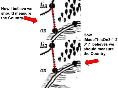
I've made an Image to Clarify How the situation is, The Wide Border isn't actually part of the Country however IMadeThis believes it is, however it is proven that Hargeon Rests on the edge of the Country, and IMadeThis's Measurement puts Hargeon not on the edge, but in the middle of the Country, which is why it is wrong
Fiore Map Measurement
Fiore Dots
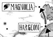
As shown here as well, Hargeon is on the edge, and there is no border, which proves the Border is not part of the Country in the Large Map
 
There are a few things wrong with using this new map.

1) That map has been retcon. This map comes from Chapter 165, thus Volume 20. The map I am using comes from Volume 27. As you can see in that older map, Cait Shelter is located south west of Halgeon which has been retconned in the newer map to be north east of even Magnolia. Thus it's no longer valid.
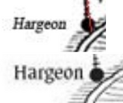
Halgeon Comparison
Torch's Calc (Top) Official English (Bottom)

2) This map has the same issue as the previous map in regards to the town Halgeon. Halgeon does not touch the ocean in either map with it's black dot indicator (images to the right).

Captain Torch, who Mitch's calc is based on, quantified the distance by using the black dot, not the border/ocean line. Torch even said this himself in a previous comment in this thread:
Halgeon Not Touching Ocean
New Map Doesn't Have Halgeon Touching the Border/Ocea

>Just to clear things up, my calculation scales to the far end of the Hargeon port town(dot), not the border.


I have been advocating on using the more recent Official English Map, which only I have been using in this discussion and in my calcs. This map shows Akane Beach touching the outer border/outline and directly touching the ocea which Halgeon Port would also be doing as Dimaria discussed and showed us the harbor/dock of Halgeon Port is touching the ocean.
 
Ok after looking at the page....it's quite confusing that's for sure hence why I can see y'all both have yur difference. Dimitra said that they have 30KM to go then she says that the distance (basically saying the same thing) is 400KM away

EDIT: nvm she meant the 400KM for FT but what is the main reason for this? The closer the dot is a upgrade or downgrade?
 
using Imade's method would make the country smaller, my method would keep the size relatively the same as it was before
 
BlackeJan said:
EDIT: nvm she meant the 400KM for FT but what is the main reason for this? The closer the dot is a upgrade or downgrade?
Despite the very small difference in size, that small difference makes a huge difference once we use it to determine a size for Fiore which we then use to determine a size for the Ishgar continent and the rest of the other countries.

That small difference changes whether the AP of Dragon Cry is under 100 Petatons or around 250 Petatons. Also, the current speed calc being used for the God Tiers is dependent on the size of Fiore and currently uses an incorrect inflated size that makes the God Tiers over Mach 4000. Not even Torch's determined size of Fiore would yield that result. Thus why it's important to get this right.
 
Cait Shelter was first introduced around chapter 131 and this map was first introduced around chapter 165. This map makes more sense when it comes to telling the position of cait shelter, since it was created few chapters after cait shelter was first introduced .

But this new map came hundreds of chapters after the original map that told us where cait shelter was, it's simply hiro forgetting where he placed cait shelter.

I will rather accept this map, when it comes to where cait shelter is rather then the new one. The new map is just hiro forgetting where he place cait shelter, and nothing more.
 
The last map wasn't retconned, that's not how it works, first of all by Chapter 230, Cait Shelter is long gone, it's no longer a guild even, So Hiro likely forgot, it also doesn't change the fact that your measurement is putting Hargeon in the middle of the Country, when in the story it is on the edge
 
@iMade

The first map is very close to when hiro first introduced cait shelter, and it makes more sense. But the new map is many chapters after, and this time hiro put it in a different place, the only explanation to this is that hiro forgot where he put cait shelter in the first place.

There has never been any mention of retcons, you came up with that idea.
 
The Map was updated by December x784, even though by this point Cait Shelter is gone, Completely, so it makes no sense, Also Magnolia and Hargeon are in the same area as they are in the big Map, and once again IMadeThisOn8-1-2017 calculates that Hargeon is in the middle of the country, and Not on the edge of the Country, because the Wide Border isn't part of the country
 
Using the newer one is what we would do as it is the more recent, thus updated canon. The older one would be retcon by the newer one. Plus, both maps still don't have Halgeon touching the border line nor the ocean which is where we know Halgeon Port to be at since Dimaria showed and told us.
 
@Sigurd

Him forgetting where he put cait shelter in his newer map makes more sense then saying that he retconned it.

Why do you think he misplace it in the first place. What proof do you have to say that he misplace it. Why would he put cait shelter close to hargeon, just to change it in a later time. Also why would hiro just place cait shelter in any random place in the first place, unless he intented it.
 
Status
Not open for further replies.
Back
Top