• This forum is strictly intended to be used by members of the VS Battles wiki. Please only register if you have an autoconfirmed account there, as otherwise your registration will be rejected. If you have already registered once, do not do so again, and contact Antvasima if you encounter any problems.

    For instructions regarding the exact procedure to sign up to this forum, please click here.
  • We need Patreon donations for this forum to have all of its running costs financially secured.

    Community members who help us out will receive badges that give them several different benefits, including the removal of all advertisements in this forum, but donations from non-members are also extremely appreciated.

    Please click here for further information, or here to directly visit our Patreon donations page.
  • Please click here for information about a large petition to help children in need.

Fiore's Proper Diameter (Very Important)

Status
Not open for further replies.
Do we have to go around and ask calc members again? I know I've talked to RavenSupreme about this off-site, but I never directed him to this actual thread. Plus:

BlackeJan said:
Well that was b4 he saw the difference though. I wouldn't be fair if someone has an ACTUAL difference and he has proof
Jan is right, Tata made his final comment before we even got into new points and even more reveals. So TataHakai would have to catch up again to make a decision.
 
Well, if you did not ask all of the calc group members the last time, you can inform the remaining ones about this thread as well.
 
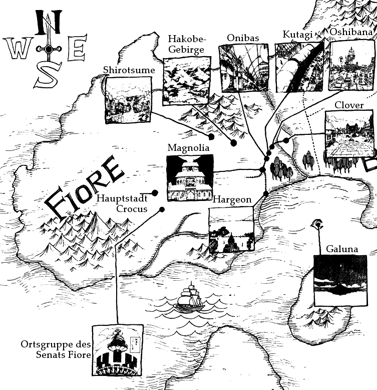
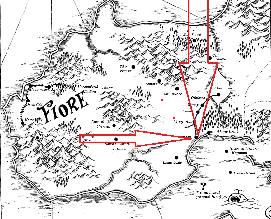
I informed some more Calc Members and reminded TataHakai since apparently no one did. I was also inspired by Mitch to edit the Fiore map showing the border I believe to be the true land border and the area of the country that we should use since Akane Beach touches the further border outline.
Fiore Map
 
The outward line versus the inner line, that is what the argument boils down to, right? If there canonically is a beach, it seems to me that the beach would be best exemplified by a line. Based on that, and with other dialogue contexts in mind... I think the outwardmost line would be best used.

I'm not familiar with the verse, but from what seems to be a minor issue over the true border, I believe the outwardmost line should suffice.
 
Yeah, no problem. Let me know if I am misunderstanding anything or if there's anything else I should know, I'll follow the thread to the best of my ability.
 
If needed, you could read the whole thread from top to bottom. We eventually ran out of arguments and points and were just waiting for Calc Members to read both sides of the discussion since we threw out everything we could to convince the other.
 
I glanced through a lot of it, images are always very helpful so thank you for that since a few images simplified the rest of the info a great deal, since much of it is just... context.
 
So which calculation blog should we use then?
 
I just want to say that I have extensively discussed this with Imade outside of the wiki. I do not believe that the two lines express an actual coast line. They are the indiactive border lines. Scaling doesnt have to go down to them.

Zooming in on the black dot also shows that right and left to the black dot are watermarks present, showcasing that the ocean reaches at least that far into the mainland. As such the southern part of the black dot from Halgeon is already part of the coast.

https://i.imgur.com/Kkqk7At.jpg

Scaling only to the black dot is what I support.

Also I do not believe the black dot right to it is supposed to be the beach. I belive the beach is where it actual is stated to be. The white part.

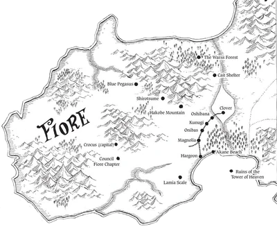
This is also supported by another map, which doesnt have the black dot from Akane Beach.

Karte_des_Landes.png
 
From what I can tell, IMade's calc uses the beach in its scaling, so I believe that is my choice.
 
If Raven is more knowledgeable on the verse, I would say take their suggestions. I for one am not at all knowledgeable and my opinion is thus secondary to Raven's. If, contextually, it makes more sense to scale directly to the black line, that should be done. I am not here for context. I just do math.
 
Here is another Map of Fiore, this time from within the Manga itself, which also doesnt show a black dot at Akane Beach -

https://12dimension.files.wordpress.com/2017/02/fairy_tail_ch522_p007-e1488110173462.png?w=640&h=414

-

We also have to considere that real life maps have the exact similar approach on Maps than the one drawn from Fiore. https://www.schottland-reisen.net/f...arte_Edinburgh_Scottish_Border_7be64341a9.png


Take a look at Edinburgh. It stops before the drawn line which represents the border. Going by the newly presented approach it would mean that it would not be at the actual coast and we would have to assume that any scaling to the coast is needed to be scaled further than the dot representing the city.

But in actuality we know that it is a clear coast city.

http://i4.photobucket.com/albums/y124/the_boy_david/leith_robert_adam_architects.jpg
 
And again probably the most important thing here:

The black water marks surrounding the black dot Halgeon is representing are eastern and western of it already present - fully justiying that all three, the harbor, the black dot, and the actual city are located at the coast itself - since otherwise water landmarks would stop straight before the southernest part of the black dot.

It further underlines the credibility of the dot being the correct scaling point and the border lines being not representative for scaling.

Fiore
 
Akane Beach appears to be on those lines though? As in, after your suggested line. If it makes sense in context, feel free to disregard me, but is the placement explainable?
 
Too summarize:

- Water marks east and west to black dot proof that black dot representing Halgeon is already at the coast and waterline - waterlines go as far as the almost highest point for the black dot

- Drawn borderline are no represantation of an actual coast but mere borders outlining where Fiore ends

- Real life Map have a similar approach on Borders with City dots stopping in front of the actual drawn border yet they are still full fledged harbor cities
 
@RavenSupreme

So which calculation blog do you prefer to use?
 
Mr. Bambu said:
Akane Beach appears to be on those lines though? As in, after your suggested line. If it makes sense in context, feel free to disregard me, but is the placement explainable?
The entire Akane Beach dot thing is pure confusion we have it on one map. The one map we use for scaling. We dont have it in any other map drawn which I remember. Also its not really important in the first place because:

Assuming that Akane Beach dot actual were a dot representing something directly at the water

it doesnt

disprove that Halgeone is NOT at the water - going by the watermarks surrounding Halgeons dot.

At best, it would show that Akane Beach is further into the water with a Beach present.

But with contradicting maps of it being present and not being present my stance is that not the black dot represent the beach but the complete white part next to it, which also has the name "Akane Beach on it".
 
Antvasima said:
@RavenSupreme
So which calculation blog do you prefer to use?
Someone here should maybe link all the other scalings from blogs. I just see the one here with the proposed change with a new pixel scaling. I disagree with that proposition but it doesnt mean I automatically belive the others are correct and should be used without having checked them.
 
@RavenSupreme

Okay.

@DemonGodMitchAubin

Would you be willing to do so?
 
@Raven

>But with contradicting maps of it being present and not being present my stance is that not the black dot represent the beach but the complete white part next to it, which also has the name "Akane Beach on it".

That's why I gave you an official English version of the map off-site, the white space that Akane Beach is written over that you keep talking about is fan scanlation erasing the Japanese Kanji to write Akane Beach on it. You can see that the white space isn't there and it's just whiting from the words., the black dot is where the beach is at.

Also this map that you've linked, I still can't find it in the manga honestly, I've been looking.

This other map you've shown is the most recent one in the manga, appearing closer to the end of the series. On this map, a lot of places are shifted around in rather different areas and we can't actually identify what is truly what, plus the map is skewed, so it's hard to use due to lack of indication, thus why we avoid using it.

If I must be honest, I can't lie that most of Fairy Tail's map of Fiore very much aren't all that consistent with each other in where everything is which is a leading cause to this problem.

If we need to take a look at each map, we can do so.
 
Thanks. So what I got from it - the most important part:

In almost all Maps Halgeons black dot is surrounded by watermarks at eiother the south, east and west. Hence the argument that its clearly touching the water and coastline is valid.

Referncing your Maps:

https://imgur.com/OQE4atS

The southern part touches the water.

https://imgur.com/AFfLT1d

The eastern part goes as high up as almost the most northern part of the black dot

https://imgur.com/CQVupP4

The eastern and western parts show watermarks next to around the middle of the black dot.

-

Exception:

https://imgur.com/qFlN81y

Halgeon is located way in the land with a clear gap to the coast.

-

So from 4 maps you linked 3 showcase Halgeon being either at the south, the east, the west or at east and west be surrounded by water.

As such, like I said,

Assuming that Akane Beach dot actual were a dot representing something directly at the water

it doesnt

disprove that Halgeone is NOT at the water - going by the watermarks surrounding Halgeons dot.

-

Given that we have clear watermarks in continuous map scans present which show that Halgeon is also directly at the water.
 
Raven, I don't think those lines are watermarks. Look at the watermarks in the ocean, they're wavy. The marks by Halgeon are straight line marks that you can see elsewhere on all the maps in the middle of the land. The lines inside the border are not similar to the lines in the ocean, thus they aren't watermarks.
 
Well I am fairly certain they are. You can even determine them going from the ocean to the land as one straight line in most of the scans. Here,

https://imgur.com/a/1JoR2hm

Not every single line, yeha. But enough to portray the authors intent clearly.
 
Well, it is up to Raven and the other calc group members to make a decision here.
 
These two don't have connecting lines. This one has like two lines that line up.

But again, these lines aren't the same marks.

In this map, the lines of the ocean are wavy. The lines on the border and inside at random places of the land are straight lines. They're different.

In this map, the lines of the ocean are wavy as well and the lines on the land are straight.

In this map, the lines of the ocean are wavy again and the lines inside the border and inside at random places of the land are straight lines.

The author is clearly making these lines different when on land and when on water, we can't say they're the same when there are lines in random spots inside the land that are just the same as the straight lines by the border.
 
I do not know. It is not my area.
 
Assuming we are disregarding what I assumed to be the beach, it should definitely be scaled to the far side of the black dot. Assuming I am understanding all of this correctly, the most recent English map does not, in fact, work with older maps. If one map compared to all others has this inconsistency, then I would say the map is invalid for the purposes of this wiki.
 
Okay. Thank you for the evaluation.
 
IMade's version used the beach, which, from what I can tell, does not line up with current standards.
 
So we'll use my calc, since mine alines with the idea of Hargeon being on the edge, and leaving out the Wide border which is just water and not part of the land at all
 
DemonGodMitchAubin said:
So we'll use my calc, since mine alines with the idea of Hargeon being on the edge, and leaving out the Wide border which is just water and not part of the land at all
Can you link your calc?
 
Thats a fair assessment. Its scaled to the absolute outer limits of the black dot. It also seems to be 500 to 700 KM less diameter than the current accepted one, which is 4.8 instead of your 41/4.2.

Have not checked the validy of the Multi-Continental Calc but apparently others have already accepted it so I will not bother with it.
 
Status
Not open for further replies.
Back
Top