• This forum is strictly intended to be used by members of the VS Battles wiki. Please only register if you have an autoconfirmed account there, as otherwise your registration will be rejected. If you have already registered once, do not do so again, and contact Antvasima if you encounter any problems.

    For instructions regarding the exact procedure to sign up to this forum, please click here.
  • We need Patreon donations for this forum to have all of its running costs financially secured.

    Community members who help us out will receive badges that give them several different benefits, including the removal of all advertisements in this forum, but donations from non-members are also extremely appreciated.

    Please click here for further information, or here to directly visit our Patreon donations page.
  • Please click here for information about a large petition to help children in need.

Fiore's Proper Diameter (Very Important)

Status
Not open for further replies.

DemonGodMitchAubin

He/Him
VS Battles
Thread Moderator
Calculation Group
15,442
15,410
So there has been some discussion on which way to calculate the Diameter of Fiore, and it effects the power of several calcs, I have heard two ways of Calculating the Diameter


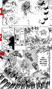
In Chapter 461 It is stated that from where Dimaria and Wall are in the story, is 30 Km away from Hargeon port, and 400 Km away from Magnolia where the Guild of Fairy Tail is
Distance Between Port and Magnolia
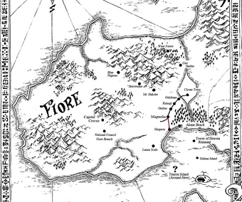
An Image of Fiore


Now the debate is whether or not, we should measure the 30 Km from the edge of the Country to Magnolia, or to the Town of Hargeon, it is a very small difference, however it is very Important, for instance it would decide whether the Distance between Magnolia and Hargeon Town is 370 Km or something lower


Now in My opinion it makes more sense to measure from Hargeon Town to Magnolia, as Hargeon Port is Hargeon Town itself and would make a lot more sense, since we have an actual marker for where the measurement would be, as well using the edge of the Country of Fiore, would dictate that the port itself is larger than the whole size of the Town of Hargeon, while in actuality the size of the port is very small compared to the Town, So I believe it makes more sense that the Distance between magnolia and Hargeon is 370 Km
 
It is much better to remove the highlight and simply ask all of the calc group members, along with DontTalkDT and Kaltias, to comment here via their message walls. Otherwise the informed voices will likely be drowned out.
 
With my calc of the size of FIore I get a diameter of 3481.7 kilometers

There are blatant reasons why it's inaccurate to measure the distance between Halgeon Town and Magnolia as 370 kilometers:

1) We are never given the distance from Magnolia to Halgeon. The only distances we get are that it's 30 kilometers from Wall and Dimaria's position in the ocean to the harbor. And 400 kilometers from their position to Fairy Tail in Magnolia.

2) The 370 kilometers is not between Magnolia and Halgeon. As Dimaria and Wall said, the 400km is from their position to Magnolia, and as they said they are already 30km away from the port town of Halgeon. The 30 kilometers is from their position to the harbor/port, thus the coastal line (bottom left panel).

Conclusion: Since the 400 kilometers is from their position to Magnolia, and the fact that they are 30 kilometers from the coastal line, this means that it's 370 kilometers from the coast to Magnolia. It is incorrect to be measuring the 370 kilometers as beginning on land like in Captain Torch's or the previous Fiore diameter calc sizes since we are literally told by Dimaria and Wall that it's the coastal line to be measuring from.
 
They say it's 30 Km to the Harbor, the Harbor is right where Hargeon Town is, in fact the Harbor is part of Hargeon itself, therefore since there is an actual marker for Hargeon on the Map, and we also know where Magnologia is, it makes logical sense to measure from Hargeon to Magnolia as 370 Km, since Hargeon has a Placement on The Map, it makes far more sense to use that then the edge of the Map that is unquantifiable
 
Because the total distance from Dimaria and Wall to Magnolia is 400 Km, and their distance to Hargeon is 30 Km, the only Measurement of Fiore we have is 370 Km from Hargeon to Magnolia, not the Coast to Magnolia, it's the only way we can measure countries
 
Using the official English version (thus higher quality) of the Fiore map. This will show us the numerous errors in Torch and Aubin's version of Fiore's diameter.

1) In MitchAubin and Captain Torch's revision they determined that Halgeon's black dot was touching the coast. This is incorrect as we can see that Halgeon's dot does not touch the coast in the official English version. This already makes Mitch and Torch's version incorrect.

2) Mitch and Torch incorrectly assumed that the closer edge of the border was the location of the coast of Fiore. This is not true because we see on that same map that there is a beach (Akane Beach) that is actually directly on the border and directly touches the the further edge of the border and even touches the ocean. For reference, Akane Beach is a regular beach, nothing special. The Harbor/Port Town in discussion would be touching the outer edge of the border and directly touching the ocean just like this beach given that Dimaria and Wall show and tell us that the 30km distance is from their location in the ocean to coastal line (we are even shown a pier with docked boats).

3) In Mitch and Torch incorrectly assumed that the Harbor/Port Town was located inside the dot of Halgeon. We aren't even told this to be quite frank. All we know is that Wall and Dimaria are south of a Port/Harbor Town of Halgeon. As we see on a higher quality map, Halgeon's dot doesn't touch the sea while this Port/Harbor Town does. Akane Beach touches the sea and this Port/Harbor Town does as well per visuals. Thus, the Port/Harbor Town would not be located inside the dot and would be touching the ocean directly just like Akane Beach.


Conclusion: The diameter of Fiore that previous 4 calcs have been using are incorrect as they incorrectly determined the location of the Harbor/Port Town. In my calc I actually accounted for all this and reached a more accurate diameter because of this realization.
 
@IMadeThisOn8-1-2017

You make a few good points but your making a big assumption, that the map you have shown is the only way to tell where Hargeon Port is

Alright, Here is Another Official Map that has an actual closeup from Hargeon to Magnolia, as you can see, Hargeon is right where the Edge of the Country is, however I admit that maps can be a bit inconsistent with each other, when debating the exact placement of the Dot, so lets take a look at the Actual Port Compared to where Hargeon is and where Dimaria is, as you can see here, The port IS Hargeon itself, the port rest right next to Hargeon Town, that's why it's called the Port Town of Hargeo, and this is proven when Dimaria says the Harbor is 30 Km away, we see an Image of Hargeon's Port right in the bottom Left corner, so she was talking about Hargeon Town, So the Town of Hargeon is around 30 Km from Dimaria and Wall, and since Dimaria and Wall are 400 Km from Magnolia, Logically the distance from Hargeon to Magnolia is around 370 Km

IMade's entire argument revolves around the Map of Fiore, and how the tiny dot is compared to the edge is a bit off, However if you notice the wide Outline surrounding Fiore and everything as well, is more than likely a border or Outline, Not actually part of the Country, therefore the way we should count pixels and calculate is by using this Method, which ignores the wide Border that is not actually part of the Country, so the Dot of Hargeon is on the edge of the Country, and you may disagree, however on another Small map as shown above, the Dot is right where the edge is, and as well, in the Anime and Manga, Hargeon is on the edge, meaning that everything alines with Hargeon being on the edge of the country, so the distance between Hargeon and Magnolia is 370 Km, as well proof of this is that The ships Dimaria and Wall were on landed at Hargeon Port, where Hargeon Is, Hargeon in the Story IS the Port and therefore the distance between Hargeon and Magnolia is 370 Km

Claiming that Hargeon Town, is Not on the Edge, is only based on a Dot that is not on the border of the Map, which actually isn't part of the Country, which isn't enough of an Argument to debunk the fact that Hargeon Is on the Edge because the Port is the Edge of the Country, and the port is Hargeon
 
Alright the way I see it we need to find a middle ground since apparently @Demon said that the maps can be inconsistent
 
^What Mitch said.

I'll bring my arguments as well, but honestly Mitch did a good job proving all this, so there's not much I can add.

As seen here , Dimaria stated "You planning on blowing up the port? We still have 30 km to go", which implies that there is still 30 km until hargeon's port. Hargeon is known as a port town, so the fact that the port is a part of the town is undeniable.

As seen on the map, the town is located where the dot on the map is.

The distance between the dot and the "edge" is as big as the dot itself, which means that either:

a)The port is a part of the dot, and the distance between the edge and town is a small inconsistency in the map

or

b1)The port is as big as the town, making Hargeon town actually double the size, and creating inconsistincies on the whole map(that would mean that the towns extend past the "dots", which doesn't make sense in a map)

b2)There is a distance between the port and the town, which is simply wrong by manga facts(Hargeon port being a part of hargeon)


Your version, Imade, actually is far more inconsistent, which makes it false.
 
There are two Maps we have, One that Puts Hargeon right at the edge, One puts Hargeon a tiny bit off of the edge, hardly noticeable that it is slightly off, so we should use the Manga and Anime to decide where it is, and the Port is right at the edge of the Country in all media in the series, so it only stands to reason that Hargeon is on the edge of the country, Hargeon to Magnolia should be 370 Km, once again we shouldn't Nitpick that the dot is slightly off compared to Edge, we should just calc that between the Magnolia Dot and Hargeon Dot, is 370 Km
 
Just a note that nothing is going to happen here unless you get the calc group members to comment. It is entirely up to them to decide.
 
>You make a few good points but your making a big assumption, that the map you have shown is the only way to tell where Hargeon Port is.

Yes and no. With the map we know where Halgeon is and we would then be able to know that Halgeon Port is located to the south of it on the coastal line.

>Alright, Here is another Map that has an official closeup from Hargeon to Magnolia,

This is an outdated incorrect map of Fiore. It has Cait Shelter listed as south west of Halgeon. Cait Shelter is located further north of even Magnolia. We shouldn't use it.

As I've explained multiple times in my own calc and my two comments here, using the official English version of the Map shows that Halgeon's dot is not touching the actual coast since Akane Beach is located on the border and directly touches the ocean.

As Dimaria and Wall explain, the 30 kilometers they are talking about is from their location out in the ocean to the coastal line, the port of the harbor town.

Using the dot of Halgeon Town and ignoring the fact that it's not even touching the ocean, thus not accurately displaying where the 370 kilometers begins, is completely fallacious.

We would have to ignore canon indications, visuals and markers if we were to begin the pixel calc to determine the 370 kilometers in the middle of land when we know it begins at the ocean.

Why would we ever do something that incorrect? Let's be reasonable and accurate and begin at the coastal line as we are shown by Dimaria and Wall and by the fact that Akane Beach touches the coastal line. The marker indicating Halegeon is not showing the location of the Port as we can clearly tell through the existence of Akane Beach's marker actually touching the ocean.
 
@Antvasima

I have already asked 5 Calc Members to contribute, I'm waiting for their responses
 
We've already pretty much presented our cases and our calcs, only thing now is to wait and see what the Calc Team deems more reasonable/accurate to them. They do have more experience than either of us in regards to such discussions/debate.
 
@IMadeThisOn8-1-2017

I hope you don't my argument against yours personally, Can we both agree to disagree and just wait for Calc Members to decide which result to go with
 
Not all, as I said we've pretty much laid out all our points, scans and calcs in regards to the diameter. At this point we should leave it to the Calc Group to determine which is more accurate/reasonable as they are more experienced in this regard than either of us.
 
PicsArt 08-26-09.45.53
Hey guys,is this pic help use? Since it shows horegeon port is a part of town and the distance between port and town is negligible it's from ft 1st chapter. I hope it help
 
I don't understand the other side's argument here

>Dimaria says they're 30 kilometers from the port and 400 kilometers from fairy tail > Thus the distance between the port and fairy tail is the 400 kilometers minus the 30 kilometer distance that Dimaria and Co's ships are at

The distance is 370 kilometers, i don't understand what the other side of the argument is trying to propose because they literally state they are 30 km from the port.
 
He's claiming that Hargeon is not on the edge of the country, since the Hargeon Dot is Not on the edge of the Map of Fiore and wants to measure to the wide outline, which would severley downplay the size of the country, However as stated above, The wide Outline surrounding the Country is not actually part of the country, and therefore it should be left out of Calculation when counting Pixels, and should be done this way This is also backed by the fact that, that Hargeon is on the edge of the Country, in the actual story
 
TataHakai said:
I don't understand the other side's argument here
The distance is 370 kilometers, i don't understand what the other side of the argument is trying to propose because they literally state they are 30 km from the port.
As Dimaria states, they are 30km from the coast. This means that it's 370 kilometers from the coast to Magnolia.

In MitchAubin and Torch's method, they used this fan translation and lower quality version of the map of Fiore. In their revision they determined that Halgeon's black dot was touching the "coast" (the closer black line). This is incorrect as we can see that Halgeon's dot does not touch the coast in the official English version. This already makes Mitch and Torch's version incorrect.

Mitch and Torch incorrectly assumed that the closer edge of the border was the location of the coast of Fiore. This is not true because we see on that same map that there is a beach (Akane Beach) that is actually directly on the border and directly touches the the further edge of the border and even touches the ocean. The Harbor/Port Town in discussion would be touching the outer edge of the border and directly touching the ocean just like this beach given that Dimaria and Wall show and tell us that the 30km distance is from their location in the ocean to coastal line (we are even shown a pier with docked boats).

So I have proposed and a made a calc that begins the 370 kilometers at the further border as that would be the correct place to start according to Dimaria and the location of Akane Beach. Using Aubin and Torch's version would have the 370 kilometers beginning in the middle of land and would be ignoring the fact that the Halgeon black dot doesn't even touch the closer border in the official English version that makes their revision incorrect.
 
Ahh ok i get it now, so one calc uses the end of the country just before the edge of the outline to Magnolia and the other uses the edge of outline of the border?

Well i would've agreed with the fact that that looks just like an outline and not actual land but it does look like the dot of the beach crosses over to the outline of the border which kinda supports the notion of using the outline.
 
The Dot rests on the Line, because it is a Beach, and it goes into the sea, Hargeons dot is only touching the line, because it is a town with a port that is only touching the sea, also if the border is part of the country why does is surround everything else, as you can see here[[1]] this Map has no wide border and shows Hargeon on the Edge, point is that Outline is not the Outline of the Country, if it was, the Hargeon Dot would rest on it, however the Dot is not on the Wide line and therefore, it should not be counted, because in the actual story Hargeon is the edge of the Country
 
TataHakai said:
Ahh ok i get it now, so one calc uses the end of the country just before the edge of the outline to Magnolia and the other uses the edge of outline of the border?
Yep, exactly. Mitch and Torch are using the former while I am using the latter.

Thanks for your input and time to fully understand both sides.
 
That makes sense to me, the beach was my only real concern with your point but yeah i agree with using the edge of the country rather than the edge of the border outline since we have other maps without the outline and the beach part is explained.
 
Alright, so we'll measure Fiore with Captain Torch's Method and use My Dragon Cry Calc, as the Official One
 
@TataHakai

So which calculation blog do you prefer?
 
@Imade

You're Nitpicking, the Dot is basically on the edge, is your argument, really relying on the fact that it's barely touching the Edge, point is, Captains Method of Calcing Fiore, goes to the Line, not just the Dot, and not the wide Border, and as for Cait Shelter, It's in different places on both Maps, and we have no idea where Cait Shelter is in the story, so we don't know which one is correct, all we have is these two maps, and since there is no other way to see where Cait Shelter is, it isn't a valid debunk for Either Maps, but that doesn't matter because Hargeon's Location is consistent on the Maps, You're just Scraping for Justifications, however more evidence points to the Wide Outline being not part of the Country, and that Hargeon is on the edge, also, TataHakai has already agreed with using Me and Captains Method, so the argument should be Over
 
@Ant He chose mine, as mine uses the Method of Diameter that he believes is correct
 
Nitpicking is our job, we strive for accuracy and consistency for the wiki.

As we see in all maps, Halgeon never touches the border nor the coast in any map.

We know that the 370 kilometers begins at the coast per Dimaria's words, so we would always have to start at the coast to accurately determine the distance. We can't use Halgeon's black dot markers ever since none of them actually touch the border/outline. It would be inaccurate and ignoring the fact that Dimaria was talking about where the water meets the dock.

To begin using the black dot that never touches the border/outline would mean that we would beginning the 370 kilometers in the middle of land which is already incorrect.

With that fact, plus the fact that you have been using a low quality version of the map when the official English version doesn't accept your notion of touching the edge and the fact that Akane Beach does touch the outer edge and the ocea means we should be using that outer edge.

I would have to ask, why would we be saying "Hey, let's use the black dot that touches the edge as the indicator" when none of the black dots ever touch the edge? Why would we say "Hey, let's ignore Akane Beach touching the ocean" when the harbor that Dimaria is talking about would also be touching the ocean and that ignoring it wouldn begin the 370 kilometers in the middle of land instead of the coast? It does not sit well with me and it would inflate the calc.
 
@IMade

I thought we agreed that we would let a calc member decide, now that he has decided, the conversation should be Over, and anyways, Captain's Measurement doesn't just go to the dot, it goes the line, so it is touching the real border, not the Wide Border which is not part of the country

So your whole argument of the Dot not touching the line doesn't work, because the way we are calcing the measurement goes to the line, not just the dot, so there should be no issues
 
So Since Tatahakai has decided that we calc Fiore without the Border, and my Calc has done so, And my Calc has been accepted, we will proceed with My Calc as Dragon Cry's True power

I think we can close this thread now
 
No Rush, just that a calc Member has decided which way to go with the Calc, and that should be that, we have an answer and we should use it
 
Status
Not open for further replies.
Back
Top