• This forum is strictly intended to be used by members of the VS Battles wiki. Please only register if you have an autoconfirmed account there, as otherwise your registration will be rejected. If you have already registered once, do not do so again, and contact Antvasima if you encounter any problems.

    For instructions regarding the exact procedure to sign up to this forum, please click here.
  • We need Patreon donations for this forum to have all of its running costs financially secured.

    Community members who help us out will receive badges that give them several different benefits, including the removal of all advertisements in this forum, but donations from non-members are also extremely appreciated.

    Please click here for further information, or here to directly visit our Patreon donations page.
  • Please click here for information about a large petition to help children in need.

Chibaku Tensei Calc Problems

M3X; baselessly accusing me of trying to lowball the calculation is not constructive.

> Kep already made a case saying that we can use 3km for mountains.

That case being what?

If we used 3,000 meters as the height for the mountains around the crater, the result would be Large Island level.
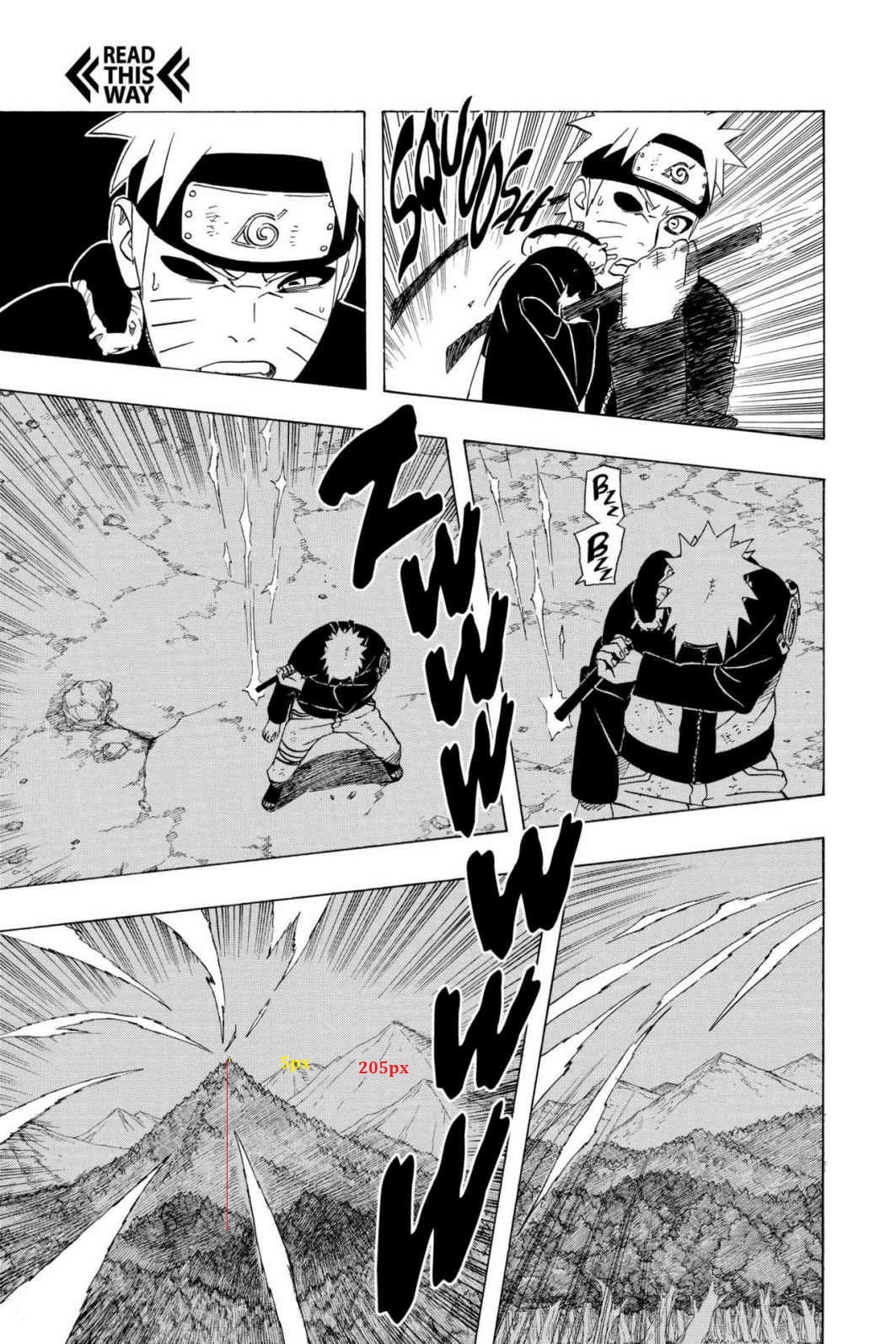
 
@M3X

Not the need to say that the man is trying to lowballed the feat. Questioning the assumption is a very good thing to progress.

Do not make unnecessary accusations, man!
 
Dzhindzholia said:
@Damage3245
Gee, thank you for the constructive dialogue.

No need to be mean dude,you can talk properly.
That's rather hypocritical of you. Your own comment added nothing of value to the discussion and felt 'mean'.
 
I said that your calc may have flaws not the other way around,how is that mean?You do calcs,so now everybody that rejects them or has something against is mean?

Nevermind,not the right place to it.
 
All you said was this:

> Maybe your calc is the one that has flaws,not the other way around.

This has no constructive purpose, so for what reason am I meant to assume that you posted it?

If you think it has flaws, comment on the calc, otherwise your comment serves no purpose.
 
I said that because we have 3 calcs with the mountain height of 3km or above and you are the only one that uses 600m.

Maybe your calc is the one that has flaws,not the other way around.
 
Okay - now you've actually pointed out a potential flaw.

I made the calc after this comment further up the thread: "Two solution here:

  • Firstly, Use the Rock Mountain in the scan with a Height of the Average mountain (609 meters)
  • Or scale Nagato's Mountain calculated with the Rock Mountain here (so basically an assumption)"
So that is why the value of 609 meters was used.

There is also another comment I noticed in a previous thread while I was browsing that said this:

> It's safe to use 609 meters if you have nothing to scale the mountain from. It's best to have a safe calc, rather than a wanked calc.

So I prefer that philosophy of having a safe calc - even if some people accuse me of 'lowballing'.
 
Damage3245 said:
M3X; baselessly accusing me of trying to lowball the calculation is not constructive.
> Kep already made a case saying that we can use 3km for mountains.

That case being what?

If we used 3,000 meters as the height for the mountains around the crater, the result would be Large Island level.
Most of the Japanese mountains go over 3km or they get very close to that size, that's several mountains. He clearly used Japan as the basis for being a series of Japanese manga. Also, as I said before, hills in the Naruto universe reach 3km, the mountains are visually larger.
 
low 6-B ST(pain weaker jutsu)>>>>>>>>>>>>>>>>>>>>>>7-A CT( pain strongest jutsu)

pain strongest jutsu weaker then his 2nd strongest jutsu

not buying it

and your calc make 0 scane

not only is your calc massed up the scaling

it also make his weak jutsu stronger then his strongest jutsu
 
The current calc is flawed since it assumes a random hill is Nagato's hideout. It's a baseless assumption that literally cant be proven. And as Damage has pointed out as well, there is inconcistencies in the art. Such as Naruto still being able to see Konoha and Konoha being visible jn the background despite the calc'd distance being over a hundred kilometers. Its visibly not true nor consistent.

With both inconsistency and baseless assumption, the current calc is flawed.
 
No. We see clearly that Nagato's hideout is very close to the gray mountains. So it is not unfounded, despite agreeing that it can not be proven! Most are on the edge of the crater and the others are just behind the gray mountains and furthest from the battlefield, and are about the same size.
It makes sense that Naruto has had to walk some distance after the fight and makes sense with the image of the tree scaling.

Having inconsistencies in image is also irrelevant... It is not motivation to completely disregard, because it had inconsistencies, especially with Naruto, where it is full of artistic inconsistencies.
 
Omimi said:
low 6-B ST(pain weaker jutsu)>>>>>>>>>>>>>>>>>>>>>>7-A CT( pain strongest jutsu)

pain strongest jutsu weaker then his 2nd strongest jutsu

not buying it

and your calc make 0 scane

not only is your calc massed up the scaling

it also make his weak jutsu stronger then his strongest jutsu
These aren't constructive arguments against the calc in the slightest. Pain's casual attacks having a higher yield then what the CT was calculated at is an invalid point and should have no bearing on whether a calc is correct or not. This alone doesn't make a calc "flawed".

Arguing that 3km should be used instead of 0.6km is valid however.
 
Something that I don't think anyone has really considered here is, that these 'green hills' that next to the crater most likely aren't even hills.

From the look of this shot here when the Chibaku Tensei starts forming, it just looks like a forest. Not masive 3 kilometer tall hills covered in forst.

To me it looks like the current calc is just scaling some trees to be 3 kilometers tall, and saying the crater must be 125 kilometers tall.

There is a some drastic inflation at work here.
 
pixel scaling>>>>>>>>assumption

Hill = 205px = 3064.955m >>>>>>>>Mountain Height = 117 px = 609 m

3064.955m Mountain came from pixel scaling unlike 609 m Mountain which is just assumption

and i am sure wiki prefer pixel scaling>>>>>>>>>>>>>>>any assumption
 
Omimi; I am not saying pixelscaling isn't worthwhile. I use it for the majority of my calcs.

I'm saying the current calc is pixelscaling the wrong thing.

Faulty pixelscaling is not preferable to a safe assumption.
 
Omimi said:
the current calc is fine

Damage3245 calc is flawed


You haven't explained why it's flawed. Unless you have something constructive to add then you shouldn't make a comment like this, especially if you aren't knowledgeable about calcs. The math on Damages blog is fine but I'm not knowledgeable about the scaling however going by the comments above there seems to be an issue. Also the entire argument that CT being Mountain level makes it invalid doesn't work. You shouldn't focus on the number but rather the math and if it's correct or not. I don't really care if the CT is weaker than his other attacks based on a calc.
 
Thank you Rin, I appreciate the comment.
 
We see that there are still traces of the forest near the crater (after its formation) and yet the CT has managed to destroy a large part.
And you can not determine that they do not have 3km, only the small start crater of the formation of the CT, can have many kilometers. And yet, the moutains are not so prominent, and yet, the chosen one is not near the CT. That's an irrelevant!

The current calculation has scaling a green mountain 3km to a small hill, which makes sense to be there, willing or not.

There is no inflation, there is a calculation where the arguments used for possible downgrades ... They are simply weak!
 
@MostPowerful; there is no argument for why we should consider a random spot of forest on the double-page spread to be a 3 kilometer hill.

Pixelscaling makes sense when it is clearly connecting objects viewed from different perspectives.

That is not the case in the current calc.
 
@Damage

Yes, there are arguments, man! I said them over there ... They make sense, so the assumption is valid! But as I told to Imade, I agree that there is no concrete evidence that this is really Nagato's hiding place, so I encourage you to scaling this "Green Mountain", the other protruding mountains around, as they have almost the same size.
 
The argument from what I gather is:

1) Nagato's hideout is based on top of a forested hill.

2) There is a section of forest near the Chibaku Tensei crater.

3) So therefore... Nagato's hideout is in the double-page shot?

If you agree that there is no concrete evidence that Nagato's hiding place is in the double-page shot, then your'e agreeing with me that the current calc is flawed.
 
@Damage

I understand your point! And yes, I agree that one of the concrete points can not be proven. However:

• The point on which the supposition is (on the actual calc), is behind a gray mountain (as Nagato's hideout is) and is far from the crater already FORMED.

Although I do not agree, it makes sense and I understand it has been approved. However, I do not agree with your calc, he gives me much more discomfort than this one.
 
Damage3245 said:
Whether the calced result is lower than one of Pain's earlier feats is irrelevant to the topic of whether the current calc is flawed.

There are no scaling problems from the Chibaku Tensei being calced at Mountain level.

The only change would be that Pain's profile would go from:

Attack Potency: Mountain level+ (Fought equally against Sage Mode Jiraiya and Naruto), far higher with a fully charged Shinra Tensei. Country level with Chibaku Tensei

to:

Attack Potency: Mountain level+ (Fought equally against Sage Mode Jiraiya and Naruto), far higher with a fully charged Shinra Tensei.
I agree with this, Chibaku Tensei isnt even an AP based ability, its literally meant to trap a target. Shinra Tensei charged up is his actual an AP ability and his best.

It doesnt matter if the yield of the CT is lower than Pain's AP:

1) Accuracy and correct math is the most important aspect.

2) CT isn't an AP based ability.

3) There is no proof the green hill is Nagato's hideout, it's unfounded.

4) The art showing the distance to Konoha disagrees with the calc'd distance. Every instance of the distance disagrees.
 
Rin The Dragon Empress wrote
the current calc is fine

Damage3245 calc is flawed

You haven't explained why it's flawed

i thought u guys check kep calc 1st. b4 agreeing how new calc is fine but i was wrong

3064.955m came from where nagato was hiding


Ada dv
 
Omimi; if you have read through my posts then you would know that I have checked Kep's calc.

My problem is that the 3,000 meters for that hill that Nagato's hideout is based on is worthless, because we don't see that hill in relation to the crater.

On top of that, Kep only uses 5 pixels for the entire height of the tree when we can only see the top of the trees in that panel that he's using for scaling.
 
@Kep; it isn't a safe assumption to make, especially when it results in a ridiculous highball as I've pointed out in the OP.

There is no connection at all between this hill you've picked out at random from the double-page shot and the hill that Nagato's hideout is based on.

On top of that, when scaling the hill that Nagato's hideout is based o, it is impossible to identity Nagato's tree on here. All we see are treetops. Claiming that these highlighted five pixels is the full height of the fake paper tree is wrong.
 
Outright false. The hill is located at the same general area the fight took place in. It is completely ridiculous to assume that this invisible and non-notable hill that the hideout is based on just so happens to be bigger than all the mountains, which you can see in the background to be bigger, especially when you see the Chibaku Tensei area.

We can't identify Nagato's tree, but we can' identify the highest point in the hill, and then make an estimate of where said highest point meets the "ground" area.
 
"Same general area", you mean about over ninety kilometers away from where the fight took place according to your calc?

I don't mean to suggest that the hill is invisible, rather that the hill is more likely to be offscreen especially since there are no defining characteristics of it that can be pointed out on the double-page spread.

The rough estimate for the size of the hill is too generous. Five pixels for the entire height of the tree? That just doesn't look accurate.

And as I've pointed out in the OP, the village is visible in shots from Naruto's and Pain's perspectives and it is way too close to be dozens of kilometers away.
 
@BlackeJan, thanks, though I did link it in the OP.
 
Back
Top