• This forum is strictly intended to be used by members of the VS Battles wiki. Please only register if you have an autoconfirmed account there, as otherwise your registration will be rejected. If you have already registered once, do not do so again, and contact Antvasima if you encounter any problems.

    For instructions regarding the exact procedure to sign up to this forum, please click here.
  • We need Patreon donations for this forum to have all of its running costs financially secured.

    Community members who help us out will receive badges that give them several different benefits, including the removal of all advertisements in this forum, but donations from non-members are also extremely appreciated.

    Please click here for further information, or here to directly visit our Patreon donations page.
  • Please click here for information about a large petition to help children in need.

One Piece Blue Planet Calc Revisions

Status
Not open for further replies.
How do we know these issues you're talking about with the different phenomenon would be visible at this scale from this 70,000 km height? That's the main issue, what other visuals from such an altitude do we have to verify the claim that they should be visible?
Alabasta and the Sandora River are visible. Drum Island alone is over 50 kilometers in diameter, the same as Sandora. The climate zone for Drum Island extends far beyond those 50 kilometers on all directions. The in-between sea beyond that before reaching Alabasta's climate zone. The would absolutely be visible.

Can you verify the claim that they wouldn't be visible at such a height? All I've been seeing is skepticism without any actual defeater points raised.
 
A Climate Zone for the Grand Line ≠ A Climate Zone for the real world.

A Climate Zone for the GRAND LINE is the climate for an area directly around the island where you can tell that there's stable climate for a nearby island.

Like yall not even reading bro and it's annoying
It does when you trying to categorize the climates for different islands and so on by the very definition of climate zones.


Just because a climate zone for the Grand Line ≠ A climate zone for the real world doesn’t stop from literally labeling the climates of the One Piece planet’s itself.
 
I already addressed this. That isn’t true
Genuine question, what do you think this large crack in Alabasta is
c0C2swz.png


Surely Oda didn't accidentally make a mark at a random spot that just so happens to be where the Sandora River runs through the island right?
 
Outside of Drum Island's immediate climate zone is where it is snowing, consistently, each time.
when we aren't seeing any signs of rainy weather above Alabasta in the bird's-eye view despite the fact that it happens right when the rain starts which happened all over Alabasta for multiple days.
Did you just say that we don't see signs of rainy weather in the arc where the entire plot point of the arc was that somebody stole the rain? And that there is no rain for the climate zone because the rain was taken away from the island, and in the panel shown there was the rain finally coming back?

Are you serious?

The clouds are beyond the birds eye view because it's showing the fall of the rain from the sky to the ground and the rain is from beyond the POV which is why it's getting closer and closer to Alabasta.
Also there's no proof that the climate zone stretches over tens of kilometers like in the image you posted and there isn't even proof that it's even the same size for all islands. That fact that Vivi considers stable weather as proof that an island is nearby kinda disproves that the climate zone would stretch that much considering Drum Island is tens of meters wide at best (due to the highest mountain in the island being 5km tall) it would make no sense for her to say that the island is nearby if we're thousands of kilometers away from an island that small.
None of this makes sense at all.

stable weather being proof that an island is close blatantly means that if there's stable weather that far out from alabasta, it's still in its climate zone
 
It does when you trying to categorize the climates for different islands and so on by the very definition of climate zones.

Just because a climate zone for the Grand Line ≠ A climate zone for the real world doesn’t stop from literally labeling the climates of the One Piece planet’s itself.
I am not measuring it by the very definition of climate zones.
I am measuring it by the very definition of climate zones, FOR ONE PIECE
yeah, because it's ZOOMED OUT.

yo are you serious?
 
So if we took the ship's average speed in the real world and applied it to the calc it would prove that One Piece ship speed is different in the real world. As if we took the real-world speed. Drum Island would likely be in the image.
 
So if we took the ship's average speed in the real world and applied it to the calc it would prove that One Piece ship speed is different in the real world. As if we took the real-world speed. Drum Island would likely be in the image.
We don't measure size that way, if we did, things like WoW's Azeroth would be so much bigger...
 
So if we took the ship's average speed in the real world and applied it to the calc it would prove that One Piece ship speed is different in the real world. As if we took the real-world speed. Drum Island would likely be in the image.
Also, the fact that they need a permanent log pose to travel to the island so they might have skipped some islands.
 
So if we took the ship's average speed in the real world and applied it to the calc it would prove that One Piece ship speed is different in the real world. As if we took the real-world speed. Drum Island would likely be in the image.
They'll say drum island is 2km wide and there's no way for it to truly be in the panel so what's the point
 
No, for Alabasta, they used an Eternal Pose to get there. The only used a log pose to get to drum island.
Canonically Alabasta is the 4th island in the log pose. they were going to use an eternal pose from little garden (the 2nd island), but then they took the regular log route after Nami got sick, and since alabasta was the next island it didn't matter
 
How do we know these issues you're talking about with the different phenomenon would be visible at this scale from this 70,000 km height? That's the main issue, what other visuals from such an altitude do we have to verify the claim that they should be visible?
Oda was able to showcase a 50km crack on the screen at that altitude. He can show anything he wants.

You guys have sat here and tried to say that the calm belt or other islands might be in the pathway when the grand line has a route of 7 islands that accompany the width of the grand line and what the OP is indirectly trying to say is that out of all 7 of those islands it's possible that each and every one is smaller than a pixel on the screen, and that each phenomenon would all be invisible on the panel

literally in every map of the one piece planet that we get we see gargantuan islands the size of half of the grand line early on in the map yet none of them actually cross over in this alabasta panel
 
I am not measuring it by the very definition of climate zones.
I am measuring it by the very definition of climate zones, FOR ONE PIECE

yeah, because it's ZOOMED OUT.

yo are you serious?
You can’t measure a climate zone when we already trying to measure the width and length of the Grand Line and all. Also there is no way to measure climate zones in that regard. The measurements for climate zones are meant for weather and atmospheric conditions as well so it is literally pointless to even go that route either way.


I just not sold on this point regardless.
 
"Which island is next on the Grand Line?" Is my question to that answer.
The reason I say this is:
1. Even if it is a piece of shit, the goldfish is stated to eat an island, so by logic, the shit should have a magnetic pull.
2. The Straw Hat Pirates, after healing Nami, go straight to Alabasta, and NOT restating the log pose. Only using the Eternal Pose.
 
You can’t measure a climate zone when we already trying to measure the width and length of the Grand Line and all. Also there is no way to measure climate zones in that regard. The measurements for climate zones are meant for weather and atmospheric conditions as well so it is literally pointless to even go that route either way.

I just not sold on this point regardless.
higurama.png


Question for you.

What do you think a climate zone is in One Piece regarding the grand line?
 
I already say what the definition of climate zone is and I will not argue anymore on the semantics of a climate zone.


You know very well, people can still do disagreements either way.
You said what the definition of a climate zone is in the real world.
I'm asking you what it is in One Piece
 
You said what the definition of a climate zone is in the real world.
I'm asking you what it is in One Piece
It still applies for one Piece, just on a different planet.

Every planet has climates and climate zones which why I not convinced by your own reasoning on why we should use the climate zone of a fictional place when we already doing the mathematics on One Piece’s planet.


Hell, just to elaborate even further, we already can described the climates of Venus, Jupiter, Saturn, Neptune, and other planets in our own Solar system alone.


I will maintain my firm disagreement entirely especially when this is technically pointless semantics here
So you don't know what a climate zone in One Piece is.
Insanely fun
 
Can you reword this? I'm having trouble understanding what you mean here. Are you saying that this panel is at an angle?
No, that's not my point. The point is that if POV isn't like super far from them, all the clouds you see will correspond to very small part of the surface you see on the panel.

With right cloud size these clouds on the panel can represent whatever area you want, so I don't get the argument of "why don't we see any cloud that'll imply climate change".
 
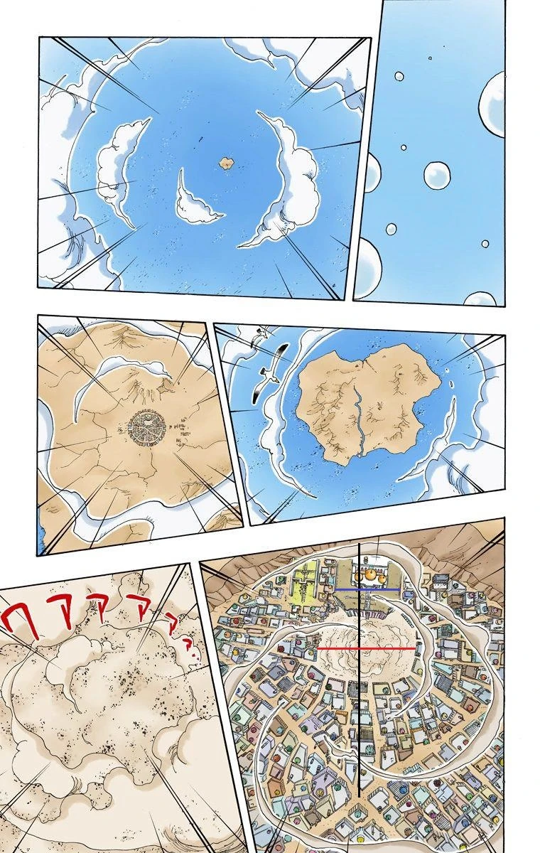
so like, the strawhats arrived at alabasta right at nanohana town which is immediately to the right of the base beginning of sandora river, meaning that from the perspective of the wide shot of alabasta, the strawhats should have arrived from the bottom of the panel in the top left image. As some people are bringing up the idea that an island like drum island would be too small to show, i do disagree since as was also mentioned, the island climates aren't just based on the island, but they do extend a good bit outside the island, and if you look at the wide shot from below the sandora river, the fact there's not a single distinct weather change is a pretty big deal indicating that at the very least, drum island just cant be located there, i feel like if oda was able to clearly show sandora river as a clear landmark, then its fair to assume he's not showing any other islands like drum because there simply aren't any around.

Granted, i don't know how valid my take is since its probably partly occams razor, but i think it could be important to consider.

but if we could at least get some kind of hyper lowball, would it be a good idea to try to use the panel in middle right to get the absolute bare minimum for the distance between drum and alabasta, since size wise I'm not sure how big drum island is but i saw some calcs putting luffys bazooka range at around 20-25km, meaning that the pixel argument shouldn't work in that middle right panel as if drum would be there then it would be big enough to show.
Sorry if this post isn't super clear

latest


Chapter 160
(this was the closest i could get to showingthe map of nanohana town, but its specifically page 5 or 6 in chapter 160 where vivi draws a visual map of the base of the river)
 
Is this not a Russel's Teapot moment?

The claim is that Drum Island and its climate zone is hidden by the clouds. It's not up to us to disprove this claim but for them to prove that this is the case.

This is also the case for the Calm Belt. They have offered 0 evidence the Calm Belt is in the panel and instead complain about not being able to prove it.

They provided 0 evidence to their argument. They complain that they wouldn't know if such stuff would be visible from the POV.

"You can't see Drum Island in the panel anywhere but its there, trust me!"

"You can't see the calm belt in the panel either but uhhh you gotta trust me!"

You can complain all you want about how you wouldn't be able to see the evidence but that's not how proving something works.

Luffy actually destroyed a solar system off screen. Huh? No, its not my job to prove it but your job to disprove it.
 
The claim is that Drum Island and its climate zone is hidden by the clouds. It's not up to us to disprove this claim but for them to prove that this is the case.
I don't think anyone claimed this to be the case; it's just something that can't be ruled out.
 
Status
Not open for further replies.
Back
Top