• This forum is strictly intended to be used by members of the VS Battles wiki. Please only register if you have an autoconfirmed account there, as otherwise your registration will be rejected. If you have already registered once, do not do so again, and contact Antvasima if you encounter any problems.

    For instructions regarding the exact procedure to sign up to this forum, please click here.
  • We need Patreon donations for this forum to have all of its running costs financially secured.

    Community members who help us out will receive badges that give them several different benefits, including the removal of all advertisements in this forum, but donations from non-members are also extremely appreciated.

    Please click here for further information, or here to directly visit our Patreon donations page.
  • Please click here for information about a large petition to help children in need.

Pixelscaling images

6,061
3,085
Trying to find a way on how to measure landscapes or the size of a certain something (like an island or city) but IDK how to really know if I'm measuring it right or how to know what the equivalent of a pixel is to a Kilometer.

Anyone that can help with this? It's also to maybe potentially upgrade stuff for a verse but also to get know how big something is in case a series doesn't mention the size of the area itself within the work.
 
First you need a base for the pixelscaling. For example, if there is a character near a crater, measure his height in pixel, the value in pixel is equal to his own height. Example

100px = 2 meters

So, 1px on the scene is 0.02 meters. Scale the crater and finish the calc. Everything is rule of 3
 
Ah. Sounds simple enough.

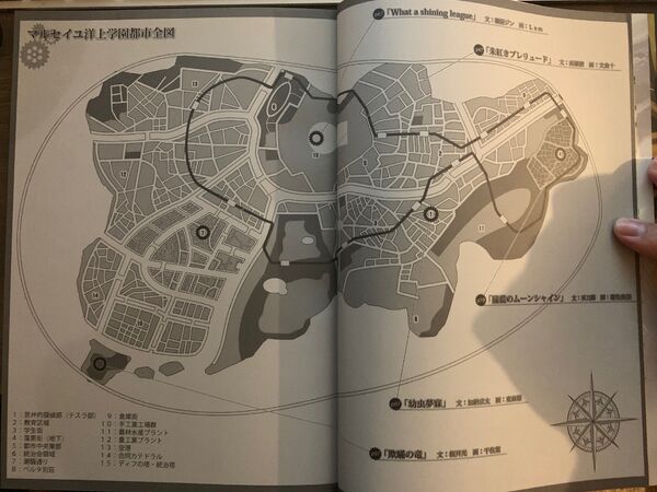
Although the problem is that it's not a particular person but rather like a map outline. It's practically flat and it's like those maps you see when going to a mall or wherever. Well in this case it's not "completely flat" cuz it's in a book and unless I want to bend it down all the way or rip them out, neither of which I want to do cuz I'm trying to perserve the heck out of it, I got to it as much to cover the whole area and try to see if I could still do that.
 
That's actually what I meant, yeah.

Map of Gahkthun (Whole)
It's this image here. The map outline in question is for Ourai no Gahkthu and primarily I was asking how I could scale it cuz this character here was gonna atomize the whole island but the work he comes from never made a stated size of the island. What's only known is that it's big enough to practically be it's own city, with 100,000 students living there with a bunch of buildings and whatnot including some thousands of feet tall steel tower.
 
Hmm. That's hard then. There is any references or inspiration from any real-life city? Or where the series take place
 
Other than the stuff I said above, only other thing is that it's off the coast of France. There is an island I know that is off the coast of France but it'd be a really small island to hold that many structures and people.
 
Well, without any measurement from the work, it is impossible to calc the size of the island. It is better if you just assume one
 
Right...

Well I don't like having to guesswork it but it's really that impossible, can't help that much then.

Thanks anyways.
 
Another thing then.

So I'm looking at other islands now, well was just a few minutes ago. Is it "possible" to get one that's similar in shape to the image above?

I could do one based on population but shape/outline seems to be the best I got out of this. So like something that ISN'T the exact same land and corners but similar enough that it could suffice?
 
Back
Top